When Do You Need a Professional Land Surveyor?
Property ownership comes with important decisions: building, buying, selling, dividing land, or resolving boundary questions. In many of these situations, hiring a professional land surveyor isn’t optional. It’s essential.
A licensed land surveyor provides verified measurements, certified drawings, and legally defensible documentation that protects your investment. At Prairie Point Land Surveyor, we help Montana property owners understand when a survey is required and why it matters.
Here’s when you should contact a professional surveyor.
Before Buying or Selling Property
One of the most common times to request a survey is during a real estate transaction. Buyers want confirmation of boundary lines, easements, and encroachments before closing. Lenders and title companies may also require a boundary survey or ALTA/NSPS Land Title Survey for commercial transactions.
A current survey helps prevent surprises after purchase and provides clarity about what is being transferred.
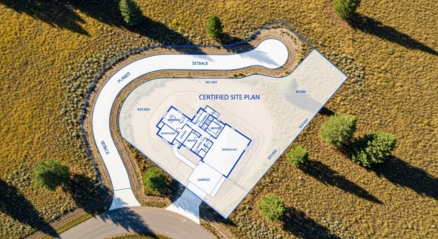
Before Building or Adding Improvements
If you’re planning a new home, garage, addition, fence, or driveway, a survey ensures your project stays within property boundaries and complies with setback requirements.
Without verified boundary data, you risk placing a structure too close to the line — or even across it. Correcting that mistake can be expensive. A certified survey drawing gives your builder accurate information before construction begins.
When Property Corners Are Missing or Unclear
Over time, corner markers can be disturbed, buried, or removed. Relying on assumptions about where corners are located can lead to disputes or costly mistakes.
Only a licensed surveyor can legally locate and certify property corners in Montana. If markers are unclear, a boundary survey restores certainty and provides documentation you can rely on.
When Dividing or Adjusting Land
Any time you plan to subdivide property, adjust lot lines, or create new parcels, Montana law requires a licensed surveyor. The **Montana Subdivision and Platting Act** governs how land divisions must be measured, documented, and recorded.
Proper surveying ensures the new parcels meet county requirements and are legally recognized.
For Engineering and Construction Projects
Engineers and contractors depend on accurate elevation and control data. **Topographic surveys, benchmark establishment, and construction stake-out surveys** are all performed by licensed surveyors.
Whether it’s drainage design, roadway layout, or utility installation, professional survey data ensures plans translate accurately to the field.
When Resolving Disputes
Boundary disagreements between neighbors can escalate quickly without reliable documentation. A certified boundary survey provides an objective, legally defensible reference that helps clarify ownership limits.
In many cases, presenting a professional survey resolves disputes without further conflict.
Why Licensing Matters
In Montana, only a licensed Professional Land Surveyor (PLS) can certify boundary locations and prepare legally recognized survey documents. Licensing ensures the surveyor has completed required education, examinations, and professional experience — and follows state standards.
Hiring an unlicensed individual to “mark corners” does not provide legal protection. A certified survey drawing signed and sealed by a licensed surveyor does.
When in Doubt, Ask
Not every project requires a full boundary or topographic survey. Sometimes record research or a consultation is enough to determine your next step.
If you’re unsure whether your situation requires a professional survey, the best approach is to ask early. Clear guidance at the start can prevent delays later.
Final Thoughts
A professional land surveyor plays a critical role in protecting property rights, supporting construction accuracy, and ensuring compliance with Montana law.
If you’re buying, building, dividing, or resolving questions about your land, working with a licensed surveyor provides the clarity and documentation you need to move forward with confidence.
At Prairie Point Land Surveyor, we deliver precise, compliant surveys backed by experience and local knowledge.
Not sure if your project requires a survey?
Contact Prairie Point Land Surveyor to speak with a licensed Montana surveyor and get clear guidance for your property.